To provide you with the best experience, cookies are used on this site. Learn more

To provide you with the best experience, cookies are used on this site. Learn more


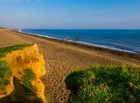
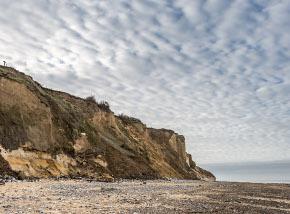
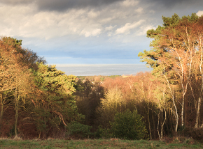
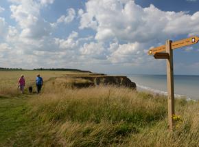
The Deep History Coast Trail covers 36km of coastline from Weybourne to Cart Gap along the clifftops of the north Norfolk coast. With eleven discovery points along the way, you can find out what the landscape looked like hundreds of thousands of years ago.
Explore the Deep History Coast along the Discovery Trail which follows the coastline from Weybourne to Cart Gap. Walk it all or pick a section and find out what the area was like thousands of years ago via eleven Discovery Points along the way. Each route brings a unique discovery about north Norfolk's past.
.jpg)
To dig a bit deeper into history, download the Deep History Coast App to follow the guided walks and meet a Hominin family and the animals they shared their life with. The App, triggered by the Discovery Points will bring the past back to life and let you see what the landscape would have looked like. The App will also provide information about facilities at each spot, including where to go to find a bite to eat. Scroll down to explore the trail.
.jpg)
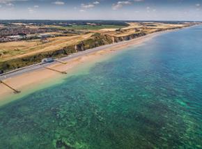
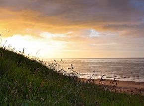
Weybourne to Sheringham
Distance: 5km / 3 miles.
Terrain: Mostly reasonably flat tract, with a slope down to Sheringham.
Description: Start at the sandy track at Weybourne Hope and walk along the crest of the cliffs heading east. This is the Cromer Forest Bed. You'll see it stretching for miles ahead like a breaking wave of land over the sea. Here, you will be walking on landscape that started to form two million years ago as the bed of an ancient river. It now holds fossils, flints and footprints that push back our understanding of prehistory by millenia. Just keep following the track towards Sheringham.
What to look out for: Towards the Sheringham end of the path, if the tide is low you can look down on Robin’s Field, an outcrop of a rare 30km-long chalk reef just offshore. The full extent of the reef has only recently been explored, and it is now a Marine Conservation Zone. It's a refuge for over 350 different species of marine plants and animals - some found nowhere else in the world.
You can see the reef by swimming out (follow safe swimming guidelines) and snorkelling to just below the surface where you may spot shoals of bib cruising over the seaweed gardens, tompot blennies peering from their holes and grazing nudibranchs. You may even come across the recently discovered species of purple encrusting sponge. The reef has an amazing complex of gullies and arches with miles of smooth white chalk, polished by the rocks, sand and gravel, ideal for exploring.
.jpg)
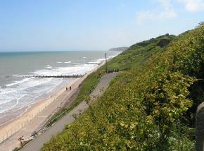
Sheringham to West Runton
Distance: 3km / 1.7 miles.
Terrain: Mostly reasonably flat paths and tracts, with a climb up from the promenade and up to Beeston Bump (approx 60 steps) and down.
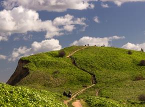
Description: The route follows the wide promenade east of the town. Don't miss the slightly hidden turn up the steps to reach the cliff top above. Here you'll find the path and steps up to Beeston Bump. The bump is actually a kame – an ice-giant's pocketful of sand and gravel left behind when the glaciers retreated. The route drops down from the hill by more steps and wends its way along the top of the cliffs, on a relatively flat, grassy path past fields and caravan parks all the way to West Runton Gap. Here, you'll find a beach and café (open mid-March to October).
What to look out for: Sheringham’s sea walls are covered with brightly painted murals of seals, fish, mammoths, boats and characters from Sheringham's rich history. They tell of a place that owes its past, present and future to the sea. Also look out for the Deep History Coast murals painted onto the side of the water tank beside Sheringham Museum. Sheringham sits in a dip of the Cromer Ridge, an eight-mile long tideline of sands and gravels left 450,000 years ago when massive glaciers retreated east and the North Sea flooded in. The ridge is up to 100m high in places and buried earlier river deposits called the Cromer Freshwater Bed. Fossils are revealed when the sea eats away at the cliffs.
.jpg)
.JPG)
West Runton to East Runton
Distance: 2km / 1.25 miles.
Terrain: Flat paths, tracks and pavements. Short section of roadsaide walking.
Description: The route starts just south of West Runton Gap slipway, following the clifftop edge and in places detours around small sections already lost to the beach. At Woodhill Park caravan site, the path diverts inland, across a wildflower meadow. Once through the park the route runs beside the main A149 through East Runton village, where this section ends.
What to look out for: The changes over millions of years show up in the earthy rainbow coloured layers in the crumbling cliffs. Many millions of years divide the chalk layer from the next you can see – this was a time when the sea was eroding the land. The chocolate brown, fossil-studded layer at the base of the cliffs, called the West Runton Freshwater Bed, is 720-650,000 years old. The sea had long receded, and this layer was laid down by a lazy estuary winding though grasslands and woods. It was in that river that the West Runton mammoth met its death over 600,000 years ago.
The bands and swirls of ochres and yellows above it tell the story of glacier after glacier advancing and retreating from the north and east, each one leaving behind the sands ground out from the rocks it passed over. But there are no fossils as the ice ages were too cold for living things to grow. Now, 10,000 years since the last glaciers melted here, a new layer has begun to form, as the sands mix with the remains of now-thriving plants and animals to form today's rich and fertile top soil.
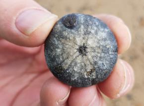
You can find fossils of sea urchins on the beach at West Runton that are over 90 million years old – and they won't look that different to the sea urchins that live in the sea today. The rock pools here provide limpets, crabs, sea anemones and starfish with their own miniature seas in which to wait out the tides.
East Runton to Cromer
Distance: 2km / 1.25 miles.
Terrain: Flat grassy paths, tracks, tarmac paths and brief roadside walking.
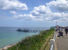
Description: This route starts at the junction of the A149 and the lane leading north to East Runton Gap, where there is parking and more information about the Deep History Coast. The long, sandy beach at East Runton is said to be one of the best in Norfolk for surfing, so it would be worth a quick detour. Just east of the junction, along the A149, the route forks left and leads through a caravan park before dog-legging along another short section of the main road then returning to the cliff tops. Once back by the coast it doesn't take long before Cromer comes fully into view. The grassy path joins the start of the genteel promenade that leads into the town itself, arriving at the entrance to the pier.
What to look out for: To the north is the 90-million-year-old chalk reef running just beneath the sea between Weybourne and Trimingham, before it dips under the land to head south. Beneath your feet is the Cromer Forest Bed, all that remains of the gravel and mud left behind by the ancient rivers and flood plains from 2.5 to half a million years ago. And to the south is the Cromer Ridge; formed around 450,000 years ago, when massive ice sheets from the north and west bulldozed a jumble of sands and gravels ahead of them as they pushed south. But this was the end of their advance – the glaciers began to melt before they could get any further, leaving behind them what are now the gentle, wooded hills of the Cromer Ridge.
Cromer to Overstrand
Distance: 3km / 2 miles.
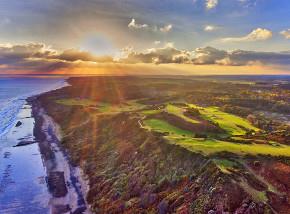
Terrain: At all but the highest tides this section of the trail can be walked along the beach. There is also an alternative route which rises steeply from the Promenade and then follows an undulating, grassy path along the cliff top at the edge of the Royal Cromer Golf Club.
Description: From Cromer Pier the route follows the promenade to its eastern end, where you'll need to decide whether to choose the beach or the clifftop for the next section. The cliffs rise to 70m at some points, and there are no opportunities to change your mind along the way.
If you choose the beach you'll enjoy nearly two miles of completely flat walking along the wide expanses of firm sand. Sea-worn wooden groynes jut out from the cliffs, but there are many gaps and low sections that are easy to cross. If you choose the high road, the route zigzags up the sloping cliffs at the end of the promenade and joins a path along the edge of the Royal Cromer Golf Club, following the dips and rises of the cliff edge. On the outskirts of Overstrand the paths join again along the seafront, where there are toilets, cafes and parking.
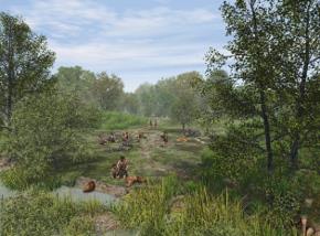
What to look out for: If you look out to sea now, can you imagine herds of wild animals grazing, or spear-wielding hunters tracking them across wild, grassy plains? Well, 12,000 years ago that's exactly what you might have seen. The North Sea didn't exist here then. Instead the land stretched all the way from the British east coast to what is now Germany and the Netherlands. Scientists have called this area Doggerland after Dogger Bank – a ridge of glacial sands and gravels in the middle of today's North Sea, left behind by that same Ice Age.
Archaeologists are examining core samples recovered from the North Sea which provide an almost unbroken record of pre-historic environmental change from the end of the last Ice Age through to the flooding of Doggerland, providing information about the environment and how hunter-gatherers would have had to adapt to the changing coastline. Using the App along the Deep History Coast will bring this area back to life before your very eyes and give you an idea of how Doggerland would have looked.
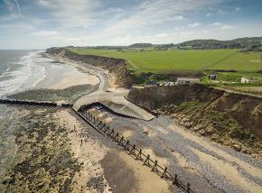
Overstrand to Trimingham
Distance: 3km / 2 miles.
Terrain: Concrete sea wall, tarmac road and pavements, grassy paths that can be muddy after rain. Some flat sections, but for much of the way the path gently undulates up and down.
Description: From the car park at the west end of Overstrand, the trail follows the broad sea wall promenade at the bottom of the cliffs to its east end, where it turns inland up a gently sloping road. After a short section walking next to the main road the route forks back along a lane past Manor Farm to regain the cliff top path. The path follows the edges of arable fields for much of the way, and can be quite muddy and slippery after rain. It winds and dips right at the top of the cliffs, and in places you'll need to divert several metres inland where it has disappeared completely. Just before you get to Trimingham the path goes through a small but pretty woodland perched right on the top of the cliffs, the only woodland section on the route. Soon after the wood, the path again turns inland to join the main road at Trimingham.
What to look out for: The gashes of white you can see in the cliffs to the right of the road from the east end of the beach here are actually huge chunks of chalk in the wrong place. They are pieces of the 70 million-year-old chalk reef which lies below the sea beyond the beach, which were disturbed by glaciers passing over it during the ice ages. Now they sit in a layer of the cliffs that is probably only a million or so years old. Keep a look out for lines of neat, circular holes in the steeper parts of the cliffs. These are the tell-tale signs that a colony of sand martins has been at work. That's all you'll see of them if you're here in the winter as the birds migrate south of the Sahara Desert in the autumn once their insect food source starts to disappear as the weather gets colder. But if you're here between mid-March and early September, you can start looking and listening for the birds themselves.
Trimingham to Mundesley
Distance: 5m / 3 miles
Terrain: Tarmac pavements, fieldside paths and tracks that can be muddy after rain. Mostly flat.
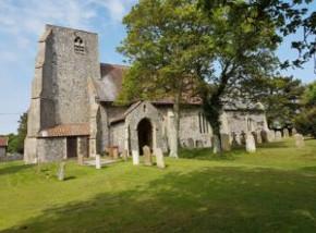
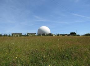
Description: From Trimingham to Mundesley much of the route veers inland, avoiding the crumbling cliff tops and the beach which is often covered by the tides. The trail begins at the west side of Trimingham near the church. At the east end, the route slips through a gap in the hedge to avoid the roadside and follows the edge of arable fields along a narrow and sometimes muddy path. The route crosses a sunken lane and joins another field edge to skirt around a giant golf ball - an RAF air defence radar station. Follow the route along the road for 1/2km before turning back to the coast for a short section along the cliffs. Once on the outskirts of Mundesley it returns to the main road, winding through the village’s back streets to emerge at the main car park by the beach.
What to look out for: Within the chalk cliffs are the fossils of some of the animals that lived in the warm seas under which the chalk was laid down – oysters and sponges, brachiopods and belemnites. Fossils are often found on the beach when the tides are low. Access from Trimingham can be difficult so it's better to walk along the beach from Sidestrand or Mundesley.
Mundesley to Walcott
Distance: 5km / 3 miles
Terrain: Firm sand beach, concrete sea wall promenades. Completely flat. Not accessible at high tide, with no official alternative route.
Description: The route leaves Mundesley along the broad, concrete promenade, before dropping down to the beach that you follow all the way to Walcott. You'll need to check the tide times before starting on this section of the route, as it's only accessible at certain times, and there is no clifftop alternative. There are gaps and low sections in all the breakwaters where you can cross, although you may have to weave across the beach between them as they don't always follow a straight line. As you near Walcott the groynes funnel you up onto another concrete sea wall path that runs all the way along the front of the village, where there are toilets, parking and cafes.
What to look out for: Cromer Ridge ends abruptly just west of the village, and as you stand on the beach here and look over to the high cliffs of Trimingham you can see where the North Sea has sliced it off like a knife through butter. There are several places along the route where you can climb to the top of the defences on wide steps that allow you to get a little closer to the cliff face. Here you can look across to see the darker, muddier-looking layer of the Cromer Forest Bed as it melts into the beach.
.jpg)
.JPG)
Walcott to Happisburgh
Distance: 2.5km / 1.75 miles
Terrain: Pavements, grassy cliff top path that can be muddy. Virtually flat. Some diversions possible as this part of the coast suffers serious erosion.
Description: As you pass through Walcott you have a choice of walking along the sand-dusted sea wall or climbing one of the sets of steps that join the pavement along the road through the seaside village above. You'll need to join this at some point, as the route bends inland with the road for a few hundred metres, before turning left to wind through a small housing estate on its way to reach the now-low cliff tops again.
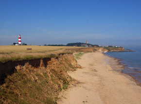
As you get closer you can see that Happisburgh spreads precariously close to the edge of these cliffs at some points. The path passes through a now derelict caravan site on the western edge of the village, then crosses meadows in front of the village to reach the car park and toilets at its eastern end. You can also take a detour through the village, where there is a welcoming pub, and in the warmer months the chance to visit the still-working 18th century lighthouse.
This is the oldest working light in the county and the only independently operated lighthouse in the UK. The famous red and white striped lighthouse is open to visitors on occasional Sundays where a climb to the top is rewarded with spectacular views of the coastline.
What to look out for: Coastal erosion is particularly voracious along this part of the coast, and some estimates put the loss at around 2km of land in the last 2000 years. Storm surges in 1953, 2007 and 2013 all bit further into the land, destroying homes and leaving the tattered edges of roads, fields and gardens.
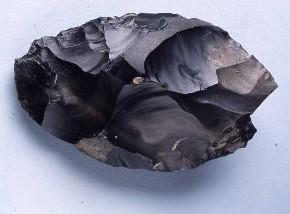
In 2000 an unusually shiny, ebony-black piece of flint that was found sticking out of the mud below the high tide line turned out to be a 500,000 year-old, skilfully carved hand axe – the oldest ever found in north-western Europe. And, in 2013, the sea stripped away the sand to expose the footprints of a family that had strolled this way, just as you are perhaps doing now, over 800,000 years ago. When visiting this stretch, the Deep History Coast App will tell you more about the significant finds in this area and how it provided a new story in our history. Please note, permission is required from any landowner prior to removing stones/rocks/fossils from the beach.
-290x214.jpg)
Happisburgh to Cart Gap
Distance: 1.6km / 1 mile
Terrain: Pavements, grassy cliff top path and stone tracks. Some diversions possible as this part of the coast suffers serious erosion.
Description:
This short cliff top walk takes in fine views of the northeast Norfolk coastline and of Happisburgh’s iconic lighthouse, the oldest working light in the county and the only independently operated lighthouse in the UK. The walk starts at Beach Road, Happisburgh and ends at Cart Gap car park.
Head out from Beach Road and along the cliff top path. Happisburgh spreads precariously close to the edge of these cliffs at some points. The path leads beside arable fields and grassy areas which in summer are enlivened with the song of skylarks and the harsh scream of swifts. Wheatears are frequently seen along the cliff top here too. One of the fields passed contains a pillbox, a remnant of coastal defences that were constructed as an anti-invasion measure during WWII. Another polygonal pillbox can be seen a little further south next to a track. The walk ends next to the cliff top cottages at Cart Gap car park.
What to look out for: Coastal erosion is particularly voracious along this part of the coast. Eroding tides have revealed flint tools dating back from between 500,000 – 700,000 years ago. Because of the large number of tools found here, this is considered to have been an important stone-working and butchery site, one of the earliest of its kind in northwest Europe. A number of wreck sites lie off this stretch of the coast including the wreck of the Revenue cutter ‘The Hunter’ which sank in 1807 and formed a sand bar until it was blown up in 1903.
When visiting this stretch, the Deep History Coast App will tell you more about the significant finds in this area and how it provided a new story in our history. Please note, permission is required from any landowner prior to removing stones/rocks/fossils from Happisburgh beach.
Explore the Discovery Trail
![]()

© Visit North Norfolk 2026. All Rights Reserved

