


Book Tickets Online
About
The 112-mile Norfolk Coast Path runs from the Lincolnshire border at Sutton Bridge to the Suffolk border, just beyond Hopton-on-Sea. Much of this walking trail runs through the dramatic scenery of the Norfolk Coast National Landscape. Experience seaside towns and villages, tidal marshes teeming with wildlife, wide sandy beaches, pine woodlands and huge skies.
The Norfolk Coast Path running from Hunstanton to Cromer is 42 miles long, and the majority of this walking trail takes you through the dramatic landscape of the Norfolk Coast National Landscape.
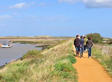
The most westerly point of the Norfolk Coast Path is the seaside town of Hunstanton. It then passes through areas rich in wildlife; the salt marshes near Brancaster, Holkham National Nature Reserve with its vast sandy beaches and pine woodland. Look out for massive flocks of pink-footed geese in the winter.
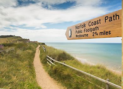
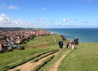
After Wells-next-the-Sea, the Norfolk Coast Path skirts along the edge of salt marshes, with views of Blakeney Point, famous for its grey and common seals. Cley-next-the-Sea marks the start of the section that follows an extensive shingle beach and wildlife-rich freshwater marshes. The route continues along the shingle beach almost as far as Sheringham, where it follows the top of the sandy cliffs, heading inland and tracking through the wooded hills between Sheringham and Cromer.
This trail combines with the Peddars Way (which it joins at Holme-next-the-Sea) to form the Peddars Way & Norfolk Coast Path National Trail, one of 15 National Trails in England and Wales.
In 2024, the entire Norfolk coast became accessible to walkers for the first time. Natural England opened the new stretch of path which covers 33.6 miles from its border with Lincolnshire at Sutton Bridge down to its border with Suffolk, just beyong Hopton-on-Sea. The section of the King Charles III England Coast Path enables visitors and local communities to enjoy and explore this remote coast, overlooking The Wash through Hunstanton, King's Lynn and Heacham, with big skies stunning sunsets and spectacular bird life.
The trail takes in:
Hunstanton Cliffs, Brancaster Staithe, Burnham Deepdale, Burnham Overy Staithe, Wells-next-the-Sea, Morston Quay, Blakeney Point, Blakeney, Cley-next-the-Sea, Weybourne, Sheringham, Beeston Regis, West Runton, Cromer, Overstrand, Sidestrand, Trimingham, Mundesley, Happisburgh and Sea Palling.
Find out more here. You can also enjoy the entire Coast Path with Google Trekker here.
Map & Directions
Public Transport Directions
Trains:
On the trail itself there are stations at Cromer and Sheringham, with regular trains between the 2 and to and from Norwich.
North Norfolk Railway (https://www.nnrailway.co.uk/) is a heritage line that also links with the Norfolk Coast Path, running between Holt and Sheringham, including a stop at Weybourne.
There is a mainline station at King’s Lynn, which links in with the Coasthopper bus and other services to the start of the trail at Hunstanton.
Buses:
Sanders’ Coasthopper (https://sanderscoaches.com/coast-hopper-information) serves a huge stretch of coastline, between North Walsham and Wells. Hop on and off the bus to explore different stretches.
Other local services help you to move between different points on path. These include Sanders 5 and 34, and Lynx 34, 35 and 36 which serve the north east coast.
General:
Visit Traveline (https://www.traveline.info/) for all public transport information including timetables for the services.
All Norfolk bus stops and train stations can now also be found on the Norfolk Trails interactive map (https://maps.norfolk.gov.uk/trails/). Click on a bus stop or train station to access timetable information for that stop.


