


The 45 mile north Norfolk coastline is constantly changing. Dating back over the last few millenia and even earlier into prehistory, the coast has changed dramatically. From a time when Norfolk was the last piece of the British Isles linked to Continental Europe, to today when coastal erosion, tidal surges and storms change the coast's landscape, there are certain places where you can see why this coastline is the most dramatic and dynamic in the UK.
Bacton. The stretch of low-lying coast around Bacton has seen a dramatic change of the last few decades when it was one of the worst affected beaches devastated by floods in 1953. Over the last 30 years, the sand at Bacton has been washed away and in Summer 2019, sandscaping (a new method of coastal protection, imported from Holland) saw nearly two million cubic metres of sand pumped from offshore to create a 6km-long dune. The height and width of the beaches have been significantly increased and access to beaches improved.
See the transformation in the video below, by Chris Taylor.
Holkham. Well known for Holkham Hall and an award-winning beach, this stretch of coast originally comprised of saltmarsh which was protected by mounds of sand and shingle. Holkham was established as a Viking settlement, but access as a harbour was stopped by reclamation of the marshes from the 17th century. To protect the arable fields, pastureland and fresh water meadows, the 2nd Earl of Leicester planted Corsican, Scots and Maritime pines in the 19th century. Today, this three-mile length of pinewoods is now an iconic landmark nestled behind the sand.
.jpg)
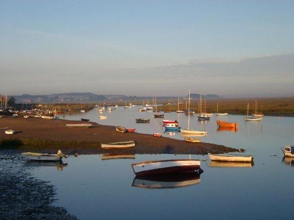
Burnham Overy Staithe. A walk west along the beach from Holkham takes you to the River Burn. This leads inland to Burnham Overy Staithe which was once a busy port for cargo ships in the Middle Ages. With the arrival of the railway in 1866, commercial shipping declined and the harbour became silted. Today, the Staithe is a recreational sailing centre.
Holme-next-the-Sea. By following Peddars Way to Holme-next-the-Sea, you will see the ancient road disappearing into the marshes. This implies that in Roman times, The Wash was much smaller and that, at low tide, travellers could walk across and reach what is now Lincolnshire. The shifting sands in 1998, revealed 54 posts sticking out the sea bed, in a circular shape. The scene was similar to Stonehenge earning the name Seahenge. Scientists revealed the construction had been in around 2050BC, when this part of Norfolk would have been ancient forest. Today Holme-next-the-Sea is an important nature reserve with a beautiful beach.
.jpg)
Blakeney Point. Blakeney Point is a sand and shingle spit, caused by longshore drift. Between 1886 and 1925 it lengthened westwards by 132 metres and it is gradually moving towards the mainland by around one metre each year.
During medieval times the spit sheltered three important ports linked to the River Glaven - Blakeney, Cley-next-the-Sea and Wiveton. Blakeney provided ships for King Edward III’s Siege of Calais in 1347 and again in 1588 when England was threatened by the Spanish Armada. In the 17th century, land reclamation schemes led to the Glaven shipping channel silting up including the tidal channel to Salthouse marshes. Packet boats ran from Blakeney to London and Hull in the 19th century until the channel became too small for the boats to pass.
Blakeney Point became Norfolk’s first nature reserve when taken over by the National Trust in 1912, and is home to the largest seal colony in England, which you can visit by boat.
.jpg)
East and West Runton. East and West Runton nestles between Sheringham and Cromer with Beeston Bump in the middle. This circular hill, known as a kame, is made up of sand and gravel deposits from an Ice Age glazier and provides wonderful views of the coast.
In 1990, the cliffs of West Runton revealed the bones from a mammoth, discovered by dog walkers. Excavation unearthed the largest, best-preserved and nearly complete mammoth skeleton known in Britain.
Fossil hunting on the beach at West Runton can be very rewarding. You may come across mammoth teeth or coprolites which are pieces of dung from animals that lived here hundreds of thousands of years ago!

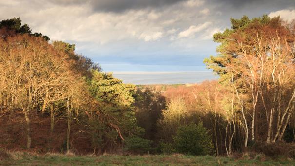
Cromer Ridge. Beacon Hill, behind West Runton, is the highest point in the whole of East Anglia and forms the pinnacle of the Cromer Ridge. This is a nine-mile stretch of upland dating back to the last ice age and was caused by a terminal moraine. A moraine is formed accumulation of glacial debris and a terminal moraine forms the snout of a glacier at which point debris, that has accumulated, is pushed by the front edge of the ice and dumped in a heap. The ridge provides a breath-taking view of the glistening North Sea.
Related
Comments
Comments are disabled for this post.
