To provide you with the best experience, cookies are used on this site. Learn more

To provide you with the best experience, cookies are used on this site. Learn more


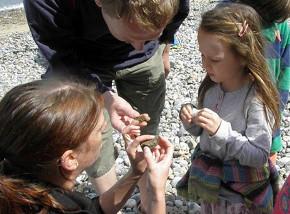
If you explore the Deep History Coast, you can find out about North Norfolk's ancient past as well as see some of it come back to life. Each part of the coast tells a different story.
The unique North Norfolk Deep History Coast is home to some of the earliest evidence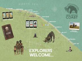 of human British civilisation with a handaxe dating back over half a million years ago and footprints from nearly one million years ago. Norfolk is also the only county in the UK where evidence has been found of the four human species - Homo antecessor, Homo neanderthalensis, Homo heidelbergensis and Homo sapiens, our own species. Visit the beach where the world's biggest mammoth skeleton remains were found and walk over land dating back to the last ice age, caused by a terminal moraine. There's so much to see and do when you delve into the Deep History Coast.
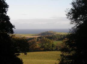
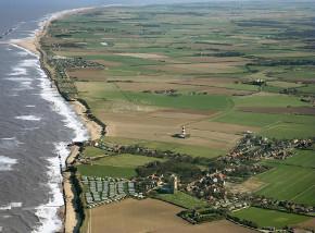
The Cromer Ridge
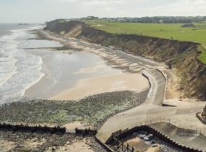
The soft cliffs of the north Norfolk coast are considered the best place to study Ice Age geology in the UK. The bedrock transitions from 65-80 million-year-old Cretaceous chalk in the west, to one to two-million-year-old Wroxham Crag in the east, both formed from marine deposits of past shallow seas.
Around 450,000 years ago, a series of ice sheets up to a mile-thick covered the whole area, leaving behind piles of sand, gravel and silt as the ice sheets retreated.
Beacon Hill, behind West Runton, is the highest point in the whole of East Anglia and forms the pinnacle of the Cromer Ridge. This is a nine-mile stretch of upland dating back to the last ice age and was caused by a terminal moraine. A moraine is formed accumulation of glacial debris and a terminal moraine forms the snout of a glacier at which point debris, that has accumulated, is pushed by the front edge of the ice and dumped in a heap.
This has left behind what we now see as unique landmarks including Beeston Bump, a round hill on the cliffs at Sheringham, the heathland lanes that are quiet and therefore great for cycling and finally, the elevated points at the National Trust’s Sheringham Park, which provides spectacular views of the coast all the way to Blakeney Point.
.jpeg)
Doggerland
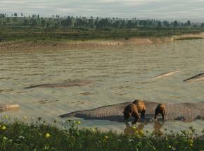
Pre-Ice Age, a land mass, known as Doggerland, connected Britain to the continental Europe and Norfolk was an upland area on the eastern edge, which linked Britain to Scandinavia. The area is now submerged beneath the southern North Sea, after it was flooded by rising sea levels 10,000 – 8,500 years ago.
This area would have been a great plain where bison, giant deer and mammoth grazed. The link to, what is now the European mainland, was lost only after the final thawing of the Ice Age which resulted in rising sea levels.
Archaeologists have recently found new evidence in the North Sea they hope will uncover the secrets of Doggerland after extracting a set of ‘cores’ from the seabed. The core samples are the most extensive ever recovered from the southern North Sea and provide an almost unbroken record of pre-historic environmental change from the end of the last Ice Age through to the flooding of Doggerland. Research into them is expected to answer questions about the environment where our ancestors lived, and how quickly hunter-gatherers would have had to adapt to the changing coastline as the British Isles became cut off from mainland Europe.
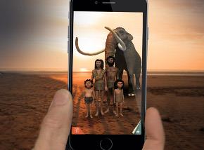
Using the App along the Deep History Coast will bring this area back to life before your very eyes and give you an idea of how Doggerland would have looked.
.jpg)
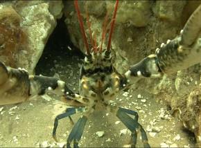
Cromer Shoals Chalk Bed
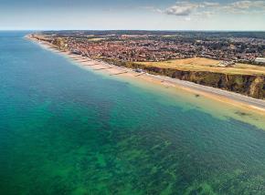
Just offshore, between Sheringham and Cromer, is the largest chalk reef in Europe and the longest in the world. At more than 20 miles long, it lies in the shallows, just 25ft from the surface and is part of a chalk stream that reaches as far as the white cliffs of Dover and the White Horse Hill Carvings in Wiltshire.
Formed during the Ice Age, the reef was created by a vast number of compressed pre-historic fossilised plankton. It is an ideal breeding and feeding ground for the famous Sheringham lobster and Cromer crab, and helps to give them a unique sweet taste.
Dubbed ‘Britain’s Great Barrier Reef’ the Cromer Shoals Chalk Bed, has recently been made a Marine Conservation Zone (MCZ) by the Department for Environment Food and Rural Affairs. It has one of the most diverse and spectacular arrays of sea life around Britain, including sponges, burrowing piddocks, sea squirts, anemones, starfish, brittlestars and fish including shoaling horse mackerel and bass.
Seasearch surveys have revealed more than 120 species of seaweed and plants and more than 350 species of fish and invertebrates. Three species never before recorded on the east coast have been found there - the Atlantic ancula sea slug, the blush-red strawberry anemone and leopard spotted goby. The MCZ means that sea life such as the threatened pink sea fan coral, which grows on the reef, will now be protected, along with hundreds of species including crabs and lobsters that colonise the soft chalk beds.
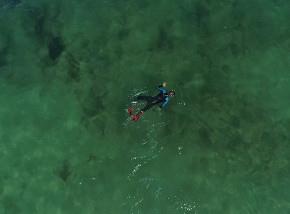
You can see the reef by swimming out (follow safe swimming guidelines) and snorkelling to just below the surface where you may spot shoals of bib cruising over the seaweed gardens, tompot blennies peering from their holes and grazing nudibranchs. You may even come across the recently discovered species of purple encrusting sponge. The reef has an amazing complex of gullies and arches with miles of smooth white chalk, polished by the rocks, sand and gravel, ideal for exploring. See local snorkler Chris Taylor's video with tips on how to make the most of your underwater exploration.
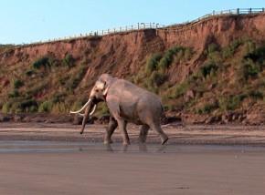
West Runton Mammoth
The discovery of the mammoth, or West Runton Elephant as it is also known, was made in 1990, when local residents Margaret and Harold Hems were walking along West Runton beach. They saw what looked like a large bone sticking out from the cliff face and contacted Norfolk Museums Service. It was identified as a pelvic bone of a large Steppe mammoth. A year later a local fossil hunter called Rob Sinclair discovered more large bones and an exploratory excavation took place, followed by a serious three-month long excavation in 1995, carried out by the Norfolk Archaeological Unit.
The exploration unearthed 85% of a mammoth skeleton, the most complete skeleton of a Steppe mammoth ever found in the world. The remains are very fragile and the majority of the West Runton Elephant lies in controlled storage at Gressenhall Museum, but there is a small display in the Norwich Castle and Cromer Museums. Further analysis of the bones revealed several interesting facts; it is known that the mammoth was a male who died at about the age of 42 in a fresh-water river bed. He would have been about 4m tall at the shoulder and weighed about 10 tonnes. The animal suffered from a damaged femur which may have contributed to its early demise. Scars to the bones also suggested hyaenas feasted on the carcass. See our top five West Runton mammoth facts.
The cliffs along the shoreline help tell the story. The changes over the years are shown by an earthy rainbow of coloured layers in the crumbling cliffs. Many millions of years divide the chalk layers during a time when the sea was eroding the land. The brown, fossil-studded layer at the base of the cliffs, called the West Runton Freshwater Bed, is 720-650,000 years old. The sea had long receded, and this layer was laid down by an estuary winding though grasslands and woods. It was in that river that the West Runton mammoth met its death over 600,000 years ago.
Beach combing along West Runton beach is great fun, often rewarded with a fossil find including fossilised sea urchins, belemnites and even amber. And the Deep History Coast App, triggered by the West Runton Discovery Point, will help you identify fossils as well as bring the mammoth back to life!
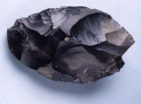
Happisburgh Hand Axe
A hand axe discovered at Happisburgh is considered to be the earliest known hand axe in Britain. Made from flint, it was the Swiss army knife of its day, used for scraping, chopping and butchering.
In 2000, a local man walking his dog on Happisburgh beach discovered the hand axe within a thick peaty deposit which was subsequently dated to between 500,000 and 700,000 years old. As a result of this history-changing discovery, excavations were undertaken by the Ancient Human Occupation of Britain project between 2005 and 2010. Further flint tools were recovered, potentially as much as 950,000 years old.
As this single discovery showed that humans had been present in Britain some 200,000 years earlier than had previously been known, Norfolk has become the focus of international attention and study for being the earliest known location for humans in the whole of north-west Europe.
The flint tool, which can be seen at Norwich Castle Museum, within the Natural History Gallery, was cutting-edge technology at the time and was as versatile as a complete set of knives today.
The hand axe was chosen as one of the objects that made up the ‘History of the World in 100 Objects’ project, a partnership between the BBC and the British Museum in 2010.
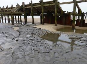
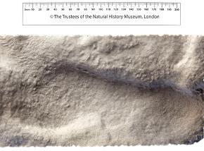
Hominin Footprints
Footprints revealed by the tide at Happisburgh indicated a group of people – most likely a family – walked along estuary mudflats between 850,000 and 950,000 years ago.
It is extremely rare for evidence of early hominins to survive so finds such as these footprints are internationally important as they can provide data about the people who left them, such as their posture, gait and size.
Hominins are classified as a tribe (Hominini) of primates, a type of mammal and are part of the family, or larger group of primates, called hominids. Hominids include orangutans, gorillas, chimpanzees, and human beings. The only hominins alive today are human beings. There are many extinct hominins; fossilized remains of extinct hominin species dating back millions of years, have been found in parts of Africa, Europe, and Asia – and also north Norfolk.
The Happisburgh Hominin footprints were examined in 2013 by a team of scientists led by the British Museum, Natural History Museum and Queen Mary University of London by making a recording of the surface through photogrammetry. This is a technique that stitches together multiple digital photographs to create a 3D map or record. The scientists concluded that this discovery was the earliest evidence of hominin footprints outside Africa.
The footprints quickly disappeared through erosion but provided the first suggestion of the body size of the earliest humans in northern Europe. Measurement of the prints suggests that their heights varied from about 0.9m to over 1.7m. Unfortunately there have not been any discoveries of human bones in Britain of this age, however the British Museum's likely identification from the footprints is homo antecessor or ‘Pioneer Man’. Bones of this early human species have been found at the site of Atapuerca in northern Spain. The importance of the Happisburgh footprints is the tangible link they give to our forebears from the deep past.
When you visit Happisburgh, you can meet a hominin family by triggering the App at the Discovery Point.
![]()

© Visit North Norfolk 2024. All Rights Reserved